NoteThe brief description below is based on a study published in 1979. It does not reflect what is in place in contemporary war-torn eastern Afghanistan. Nuristanis today are devout Muslims and were the first Afghanistanis to successfully revolt against the recent communist regime. The almost constant warfare since that time has resulted in large numbers of refugees.According to Barnett Rubin, Director of Studies at New York University's Center for International Cooperation: "Much of Afghanistan's agriculture is dependent on irrigation . . . The irrigation works require constant maintenance and when people leave, the irrigation works aren't maintained. There is a huge amount of capital that probably can't even be measured, that has been destroyed. Whole orchards are cut down, a lot of trees have been destroyed for military purposes . . . there has been terrible deforestation." BackgroundNuristan is located in the rugged mountains of the Hindu Kush in northeastern Afghanistan. The region is fortunate to lie far enough east to benefit from precipitation from the fringes of the Indian summer monsoon. Because of this, much of Nuristan, unlike the rest of Afghanistan, is well covered with trees. The characteristic topography is high mountain ridges separated by V-shaped valleys.The region is one of a chain of ethnic enclaves that line the mountains of the Indian Plate collision zone from Afghanistan to Southeastern Asia. It is the homeland of a unique group of Indo-European-speaking tribal peoples who fled Islam as it spread eastward. In 1895-96 the Nuristanis were finally conquered by the Afghan armies of Amir Abdur Rahman Khan, and the people were obliged to abandon their ancient religious beliefs in favor of Islam. In Nuristan there is a strict division of labor; men and women have very different roles. A man will not normally engage in 'women's work' any more than a woman will normally have anything to do with 'men's work'. This division of labor exactly matches the main spheres of the Nuristani economy: livestock herding (men's work) and grain production or irrigated terraces (women's work). Irrigation SystemsMuch of the irrigation occurs on small terraced fields that are laboriously constructed by filling to horizontal behind stone walls. Because rainfall is insufficient, the fields are watered by a complicated system of open channels and wooden aqueducts (ie. hollowed-out logs) leading from the rivers or, more commonly, from the tributary streams (see figure 1). The wooden aqueducts are technically and aesthetically admirable, having been constructed by skillful craftsmen.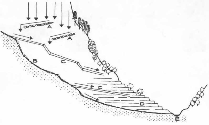 Figure 1.
Cross-section of a typical valley with a small tributary valley showing:
(a)rows of stones to catch run-off from the large rock surfaces above; (b)tributary stream; (c)wooden channels; (d)terraced fields; and (e) main river. The terraced fields, edged by low earthen balks, are sub-divided into small shallow basins. There are small openings in the balks stopped up with soil, which is removed while the basin is filled with water. Then the soil is replaced and the neighboring basin filled up. These balks are rebuilt each Spring after sowing. Wheat and millet often grows rather densely on the balks because they have been made by scraping fertile soil from the surface of the field. Sometimes beans or peas are planted on the balks, so that the crop growing in the basin is surrounded by a row of legumes. Mulberry and walnut trees often grow on the small terraces. Small tree sprouts are encouraged and protected because when grown they provide shade, add humidity to the air, and provide a needed addition to the diet. A chart showing the flow of energy in a typical Nuristani village is shown in figure 2. Note at the center of the energy flow is a water mill. 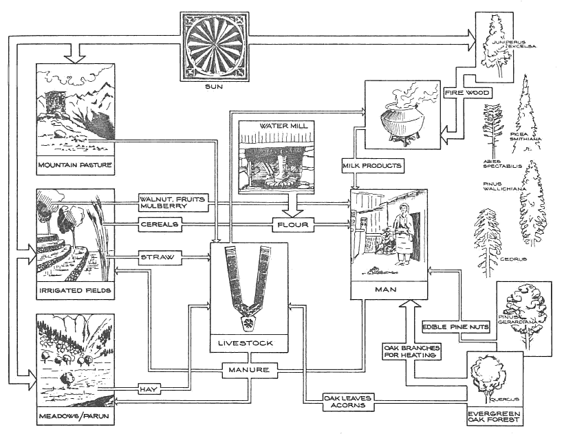 Figure 2.
The broad paths radiating from the sun represent the
flow of energy to the Nuristani landscape causing photosynthesis. Two other broad paths show the energy flow from the forest to the Nuristani community. Finally, the broad path from the windmill represents the only mechanical energy used in Nuristani society. ConclusionsNuristani villages are of special interest because of the way they fit harmoniously into their natural environment–the steep forested mountain ridges of the Hindu Kush. The mosques, houses, mills, and wooden aqueducts are not only fine examples of architecture, but are designed to withstand the region's frequent earthquakes region. An important component of the harmony are the region's irrigation delivery system and terraced fields. |

We are having rare studies on Nuristan and facing difficulties accessing to sources that study Nuristan, hence this blog was created to explore the unique history, culture society, custom, people and political situation of Nuristan.
May 23, 2012
Irrigation in Nuristan
Subscribe to:
Post Comments (Atom)
This comment has been removed by the author.
ReplyDelete